|
Tips to help you connect your family to nature!
|
|
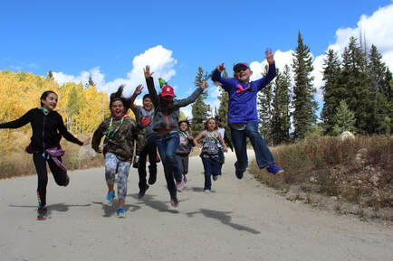
Students from Paonia Elementary enjoy a fall hike on the Grand Mesa National Forest. It can be a bit daunting to choose an area to explore with kids in our nearby national forests, to say nothing of deciphering maps and determining appropriate trails for youngsters. Between the White River, and the Grand Mesa, Uncompahgre and Gunnison National Forests, there are over 5 million acres of U.S. Forest Service lands here in Western Colorado; so vast that one may become overwhelmed with the plethora of opportunities. To narrow that down a bit I want to share with you my favorite “Hiking Gems” for kids here in our beautiful backyard on the Grand Mesa National Forest. As there are two counties splitting the Grand Mesa, I’ll give you a peek at hikes by county.
At the top of Delta County is the Land o Lakes Trail on the south side of Highway 65. This is a very short hike but gives the best view of Island Lake and the topography all around. Kids like it because it’s SHORT, handicapped-accessible, and it boasts not just a view but lots of trees and flowers to identify--don’t forget to bring The Rocky Mountains Field Guide reference book or tri-fold, both of which are available at the Grand Mesa Visitor Center. Also at the top of the Grand Mesa is the cross country ski area called appropriately County Line, which sits on the Delta and Mesa County Line. It’s advisable to do some planning by visiting the Grand Mesa Nordic Council website (gmnc.org/trails/skitrails) where you can print the map for all three ski areas. For the kiddos, I recommend the easy hike around the dog loop trail for a wonderful woodland experience, or the Overlook Trail for those able to cover more distance. The San Juan and Raggeds Mountain vistas are gorgeous from the overlook viewpoint. Mountain biking on the County Line Ski Trail system is also great fun for those of you who love the sport. I recommend reaching out to COPMOBA for recommendations based on the age and skill of your kids (www.copmoba.org). The most famous of the Grand Mesa trails is the iconic Crag Crest Trail found just up the hill from the visitor center—there is a Crag Crest parking lot sign on Highway 65, so you can’t miss it. Crag Crest is renowned for the views, the wildflowers, trees, and the varied landscape. In fall, the golden, fiery orange leaf colors can be simply gorgeous. The almost 11 mile loop may be too much for most youngsters, and even the 6 mile one way trek can be a lot. But, no one says you can’t hike out of the parking lot and up the trail as far as you want to go—you might just get close enough to the rocky top to really take in the beautiful vistas. It’s truly an exhilarating hike for everyone! Also on that side of the Grand Mesa is Island Lake. There you find a well-marked shoreline trail, taking off directly across from Island Lake Campground and going along the south side of the lake. Due to some higher-than-normal winds in past years, there are still downed trees. , but they’re easy enough to climb over or hike around. Watch for informational signs that tell fish stories that are indeed true AND remarkable. Access the trailhead via Forest Service Road #110, and park just past the trail entrance in the boat ramp parking area. In addition to the lake trail, you can walk into the Island Lake Campground and over the hill to the east where you’ll find Little Gem Lake with beautiful wild grasses, wildflowers, and peaceful waters just perfect for skipping stones and picnicking. Or, take a walk all the way through the campground heading south. There you’ll find an improved off-road vehicle lane to the Granby Reservoirs with many lakes on this 8 mile one-way hike. Consider it an all-day affair; go the distance or just a little ways, and toss in your fishing line when you stop for lunch. It’s easy walking! . The visitor center boasts the super kid-friendly Grand Mesa Discovery Trail. It departs from the visitor center and travels through woods and meadows, providing views of two lakes, seasonal wildflowers galore, and a few panels with nature information along the way (be sure to pick up the Discovery Trail pamphlet before you head out). The trail is only a third of a mile, so even the littlest can participate. While you are there, make a stop at the visitor center to learn the facts, history, and some of the excitement that Grand Mesa has to offer. The turn-off to the visitor center continues on to the Ward Way picnic area just past the campground. There you can pick up the Baron Lake Trail which passes Alexander Lake and takes you to Baron Lake. Its 1.3 miles one way but there are two places to stop and throw in a line. Or just rest a spell and examine the bug and fish life in the two lakes. Shore access is unhindered, and an easy spot for kids to play and explore. Now let’s go hiking on the Mesa County side, starting at the top and working our way down. As previously mentioned there are some great hikes following the ski trails, and while the Sky Way Ski Trail system of the Grand Mesa Nordic Council has more ups and downs and rocky business, it has a completely different view. Again, print out the map online and follow the trail to the Sunset Overlook. It’s just so gorgeous on a blue sky day in the fall—you’ll be looking down off the Mesa towards all the geologic outposts of the Bookcliffs on the Grand Junction side of the mountain. So worth the view, and it will be a new view to those who are not skiers in this area. Down the hill a bit is the Mesa Lakes and Jumbo Lakes area. There are multiple hikes in the area, all of which are kid-friendly. Turn into the Mesa Lakes area to access the 1.5 mile Mesa Lakes Shore Loop Trail. Stop for a toe dip in the cold water. This trail intersects with Lost Lake Trail for an additional 1.5 mile hike. This is one of my very favorite hikes to take with kids. It’s a bit more challenging than the Shore Trail. You can cut off the beginning hike by driving to the Glacier Springs picnic area at the same turn off as Mesa Lakes. Here the fun begins over basalt fields and through forests, and finally to the hidden gem of Lost Lake. While you are here, call out for an echo, cast out for a fish, or just get out your pen and paper and write a few Lost Lake inspired haikus. It’s a truly lovely place. Further south is the turn off for Jumbo Lakes Campground with two big pools of water: Jumbo Reservoir and Sunset Lake. The campground is between them and has parking. It’s a super fun outdoor playground for kids with creeks, bridges, lakes and varied terrain to explore. There are lots of stone skipping possibilities as well. If you are interested in a longer moderate level hike with lots of different terrain you can take off from the Mesa Lakes area on the Glacier Springs Cut-Off trail and head out to the Rim View Trail, or you can start at Sunset Lake in the Jumbo Lake Campground area and hit the Rim View Trail. It’s an out and back hike with wildflowers and rocks, and the ultimate view as you get past the connector trails. Bring your lunch and plan a picnic on a viewpoint of your choosing—you will not be disappointed. For the ultimate adventure with your kids, I’d like to recommend a one day backpacking trip. In actuality you can go for a couple of days on this trail if you wanted. Just off of Lands’ End Road you’ll find Carson Lake area and by taking the footpath across the dam you’ll find the Kannah Creek Trailhead. Hike downstream on the trail until you are tired and have gone far enough (considering it’s an uphill climb out in the morning). Find a flattish spot near the creek and set up camp. My grandson still considers this his most “wild” adventure and can’t wait to show this quick overnight out of doors adventure to his younger sister. The Kannah Creek Trail goes all the way down the mountain, but I don’t recommend it for the kids. The sounds of the wind in the tall trees, the water rushing down the mountain, the birds, and the crackling fire (when safely constructed and extinguished) make for a perfect, easy, fun introduction to backpacking. Most of this trail information and maps can be found on line at https://www.fs.usda.gov/Internet/FSE_DOCUMENTS/stelprd3812898.pdf with a printable brochure and map. Included on the map are road and route numbers. I’ve hiked all of these trails and I know you and your young folks will enjoy getting outdoors to discover the hiking gems of the Grand Mesa. Don’t be daunted by the vastness of our forest service lands—you got this, so get out there, and bring the kids!
1 Comment
|
Blogs for Summer! DIY Summer Camps A Summer backyard Bucket List Hiking with Children 101 Kids, Dogs and Hikes a Winning Combination Getting Outdoors is Easier than You Think Categories
All
Archive
Archives
July 2024
|


 RSS Feed


